
Showing posts with label Arches NP. Show all posts
Sunday, 21 October 2007
Arches - tourism day one
Arches Kansallispuisto ja Canyonlands ovat Colorado ja Green jokien alueen geologisia kummajaisia. Tässä lyhyesti, mitä Archesissa on tapahtunut, viime aikoina:
Arches, kuten muukin Colorado tasanko, on vanhaa merenpohjaa. Meri vetäytyi, ja jätti kerroksen suolaa jälkeensä. Alue aavikoitui, ja hiekkadyynit pakkaantuivat ja kivettyivät kerroksittain, muodostaen alueelle tyypillisen hiekkakivikerrostuman. Alla oleva suolakerros vajosi, liukeni tai muuten vain katosi hiekkakiven alta (en ole ihan varma kuinka) ja koko tasanko romahti alaspäin. Romahdus aiheutti samansuuntaisia halkeamia hiekkakivessä. Seuraavaksi koko tasanko nousi ylöspäin, maankuoren liikkeiden seurauksena, ja olemassaolevat kivihalkeamat 'aukesivat', synnyttäen 'lapoja', pitkulaisia samansuuntaisia kiviharjanteita, joiden reunat vesi ja eroosio söi pyöreiksi ja syviksi.
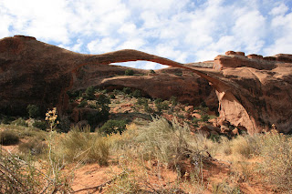
Alueelle nimen antaneet kivikaaret ovat näistä 'lavoista' kulumalla syntyneitä. Sama vesi, joka hioo lapojen reunoja, syö pehmeää kiveä niiden keskeltä, ja romahduttaa lapaa sisältä ja altapäin. Näin lavan yläosa jää kaarena pystyyn, kun taas kivilavan sisäosa häviää pikkuhiljaa. Ylläoleva Landscape Arch itse asiassa on viimeksi pudottanut kiviainesta vuonna 1995, säikäyttäen ryhmän alla istuneita, lounastavia turisteja. Onneksi kiven pauke ja narina hälytti jengin ajoissa juoksuun, kukaan ei jäänyt alle. Kaari on nyt siis olennaisesti ohuempi kuin 15 vuotta sitten, ja alle ei saa enää mennä. Muihin kaariin vastaavaa kieltoa ei ollut.

Kaaria on kaikenkokoisia ja näköisiä joka paikassa, pienen kävelumatkan päässä puiston päätieltä. Näitä kuvia riittää.
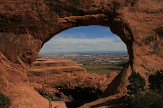
Näillä kaarilla on helppo pelleillä maisemakuvia suunnitellessa. Takaa voi näkyä vaikka mitä.
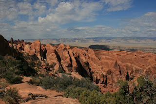
Yllä näkyy hyvin kivilapojen samansuuntainen muodostelma. Lapojen ja kaarien välistä sadevesi kuluttaa irtonaista ainesta pois, ja talvella jäätyvä vesi murtaa kiveä pikkuhiljaa hiekaksi.

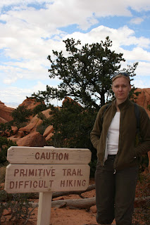
Osa kaarille vievistä poluista oli merkattu 'primitiivisiksi'. Toisin sanoen, polku ei ollut päällystetty ja ojitettu. Tällaiset varoitukset saattavat aiheuttaa inflaatiota varoituksien tehossa :)
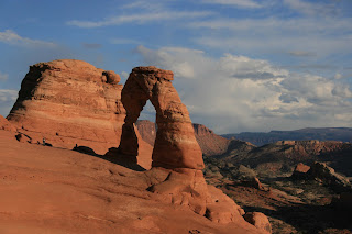
Ja viimein, Delicate Arch, Utahin osavaltion epävirallinen symboli. Paras valokuvaushetki kuulemma juuri auringonlaskun aikaan. Tästä jouduimme hiukan luistamaan, sillä taivas oli melkoisen pilvessä. Jätimme joukon toiveikkaita turisteja kameroineen odottamaan auringon viimeistä pilkahdusta, toivottavasti ei turhaan. Kaari on valtavan (jalkapallokentän kokoisen) hiidenkirnun kupeessa. Todellinen maamerkki, joka harvoin pääsee itse kuvaan.
Arches, kuten muukin Colorado tasanko, on vanhaa merenpohjaa. Meri vetäytyi, ja jätti kerroksen suolaa jälkeensä. Alue aavikoitui, ja hiekkadyynit pakkaantuivat ja kivettyivät kerroksittain, muodostaen alueelle tyypillisen hiekkakivikerrostuman. Alla oleva suolakerros vajosi, liukeni tai muuten vain katosi hiekkakiven alta (en ole ihan varma kuinka) ja koko tasanko romahti alaspäin. Romahdus aiheutti samansuuntaisia halkeamia hiekkakivessä. Seuraavaksi koko tasanko nousi ylöspäin, maankuoren liikkeiden seurauksena, ja olemassaolevat kivihalkeamat 'aukesivat', synnyttäen 'lapoja', pitkulaisia samansuuntaisia kiviharjanteita, joiden reunat vesi ja eroosio söi pyöreiksi ja syviksi.

Alueelle nimen antaneet kivikaaret ovat näistä 'lavoista' kulumalla syntyneitä. Sama vesi, joka hioo lapojen reunoja, syö pehmeää kiveä niiden keskeltä, ja romahduttaa lapaa sisältä ja altapäin. Näin lavan yläosa jää kaarena pystyyn, kun taas kivilavan sisäosa häviää pikkuhiljaa. Ylläoleva Landscape Arch itse asiassa on viimeksi pudottanut kiviainesta vuonna 1995, säikäyttäen ryhmän alla istuneita, lounastavia turisteja. Onneksi kiven pauke ja narina hälytti jengin ajoissa juoksuun, kukaan ei jäänyt alle. Kaari on nyt siis olennaisesti ohuempi kuin 15 vuotta sitten, ja alle ei saa enää mennä. Muihin kaariin vastaavaa kieltoa ei ollut.

Kaaria on kaikenkokoisia ja näköisiä joka paikassa, pienen kävelumatkan päässä puiston päätieltä. Näitä kuvia riittää.

Näillä kaarilla on helppo pelleillä maisemakuvia suunnitellessa. Takaa voi näkyä vaikka mitä.

Yllä näkyy hyvin kivilapojen samansuuntainen muodostelma. Lapojen ja kaarien välistä sadevesi kuluttaa irtonaista ainesta pois, ja talvella jäätyvä vesi murtaa kiveä pikkuhiljaa hiekaksi.


Osa kaarille vievistä poluista oli merkattu 'primitiivisiksi'. Toisin sanoen, polku ei ollut päällystetty ja ojitettu. Tällaiset varoitukset saattavat aiheuttaa inflaatiota varoituksien tehossa :)

Ja viimein, Delicate Arch, Utahin osavaltion epävirallinen symboli. Paras valokuvaushetki kuulemma juuri auringonlaskun aikaan. Tästä jouduimme hiukan luistamaan, sillä taivas oli melkoisen pilvessä. Jätimme joukon toiveikkaita turisteja kameroineen odottamaan auringon viimeistä pilkahdusta, toivottavasti ei turhaan. Kaari on valtavan (jalkapallokentän kokoisen) hiidenkirnun kupeessa. Todellinen maamerkki, joka harvoin pääsee itse kuvaan.
Wednesday, 3 October 2007
Day Two
I didn’t plan on climbing today as I knew that I’d be having 3 days of intense climbing on the Splitter Camp. I did have one aim of the day and that was to wash, after travelling, sleeping in the car and having sand adhere to every exposed part of my skin, I was stinking and washing was a high priority. Again, I woke up before 5am and decided that I’d just get on with it. I was camping by the Colorado River and couldn’t think where else I could bathe. One slight concern was that the Colorado River is dark brown, and I was scared that all I’d achieve is replacing skank with mud. I gingerly tipped my feet in, pulled them out, shone the torch on them, and was pleased to see that they were clean. I washed quickly in water which was less cold than I thought, but still didn’t feel welcoming. Leaving the water was tricky as the bank was just wet mud and involved some boulder hops on muddy boulders. But I felt wonderfully refreshed and felt clean from head to ankle (the feet were unavoidably muddy).
I decided to do a bit of touristing and headed to the Arches National Park. Of course I wanted to see some of the routes that I hope to do with Anni. I was conscious not to take photos because this is something that we’ll do together. I did spy Owl Rock. The route on the West flank goes up the rather wide crack at 5.8. It’s the easiest tower in the desert and one that we should definitely do. I was also pretty impressed with the slightly harder Chinese Eyes.
I then hiked one of the short trails. One of my whinges about a lot of so-called tourist places is that nature is somehow dumbed down for the general population. It’s fine for some people to go to the local reserve and follow the blue fir cones. But, I find the markers visually intrusive and I prefer to see a greater reliance on ones whit, rather than a wilderness for kindergarten approach. I didn’t hold much hope for US National Parks. I was completely wrong. I chose what was called the Primitive Trail, and yes there was probably a clue in the name, it said that it was strenuous (5km) and that the trail was marked by cairns. It was fantastic, the cairns were small, the path poorly developed and I hate to admit it but I had to work hard to locate the route. It went past some fantastic arches which would be very photogenic. I only saw 2 other people on the trail. Anni, we should do this with the camera, it will be great to have images of the Arches without tourists or without blue fir cones. I then went to the visitor centre and there was loads of information about the geomorphology of not only the Arches National Park but the surrounding area. Full marks for the National Park Service, I came away a very contented visitor.
I decided to do a bit of touristing and headed to the Arches National Park. Of course I wanted to see some of the routes that I hope to do with Anni. I was conscious not to take photos because this is something that we’ll do together. I did spy Owl Rock. The route on the West flank goes up the rather wide crack at 5.8. It’s the easiest tower in the desert and one that we should definitely do. I was also pretty impressed with the slightly harder Chinese Eyes.
I then hiked one of the short trails. One of my whinges about a lot of so-called tourist places is that nature is somehow dumbed down for the general population. It’s fine for some people to go to the local reserve and follow the blue fir cones. But, I find the markers visually intrusive and I prefer to see a greater reliance on ones whit, rather than a wilderness for kindergarten approach. I didn’t hold much hope for US National Parks. I was completely wrong. I chose what was called the Primitive Trail, and yes there was probably a clue in the name, it said that it was strenuous (5km) and that the trail was marked by cairns. It was fantastic, the cairns were small, the path poorly developed and I hate to admit it but I had to work hard to locate the route. It went past some fantastic arches which would be very photogenic. I only saw 2 other people on the trail. Anni, we should do this with the camera, it will be great to have images of the Arches without tourists or without blue fir cones. I then went to the visitor centre and there was loads of information about the geomorphology of not only the Arches National Park but the surrounding area. Full marks for the National Park Service, I came away a very contented visitor.
Subscribe to:
Posts (Atom)

